
Know the exact distance between La Romana and Punta Cana
Quick answer: La Romana is ~70–80 km (43–50 mi) from Punta Cana. By car via Autopista del Coral (DR-3) it’s typically ~55–60 minutes in normal traffic.
Where Exactly Is La Romana vs. Punta Cana?
Both are on the Dominican Republic’s southeastern coast. The most direct connection is the Autopista del Coral (DR-3)—a modern 4-lane highway that links Punta Cana/Bávaro with La Romana and Bayahíbe.
Distances & Typical Travel Times
- Punta Cana (general) → La Romana (city): ~70–77 km, ~55–60 min by car.
- Punta Cana Airport (PUJ) → La Romana (city): ~76–77 km, ~55–60 min by road.
- Bayahíbe (La Romana Province) → Punta Cana: ~68 km, ~50–55 min by car.
Tolls: Expect at least one Coral Highway toll (Category 1 cars ~RD$100); depending on your exact route you could hit additional booths. Carry small change in DOP.
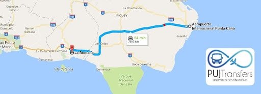
Visual Route: Punta Cana → La Romana (Autopista del Coral)
Open step-by-step directions on Google MapsDriving snapshot (most common):
- Exit PUJ via Boulevard Turístico del Este →
- Merge onto Autopista del Coral (DR-3) westbound →
- Follow signs to La Romana / Bayahíbe → take your city or resort exit.
The DR-3/Coral section is the standard route linking Punta Cana ↔ La Romana.
FAQs: How Far Is La Romana from Punta Cana?
Is it an easy drive?
Yes—Autopista del Coral (DR-3) is a modern 4-lane highway purpose-built to connect the east coast (Punta Cana/Bávaro) with La Romana/Bayahíbe efficiently.
How long from PUJ airport to La Romana resort areas?
Plan ~55–60 minutes in typical conditions, plus time for hotel gates/check-in.
How much are tolls?
Budget ~RD$100 for the Coral Highway, with possible additional booths depending on your exact route. Carry small DOP bills/coins.
Is there a direct bus?
Sources indicate a direct bus from PUJ to La Romana (Sitrabapu terminal) with daily service—always confirm locally as schedules can change.
